Assessing UAV, UGV and Field Communications Assets in Multi-Aspect Search & Rescue Operations
Harris Georgiou*, Alexios Vlachopoulos, Anastasia Andriopoulou
Hellenic Rescue Team of Attica (HRTA)
DOI: 10.37722/IJRAE.2026102
Watch the Article in Motion
Abstract
In Search & Rescue (SAR) operations, both speed and efficiency are equally important when it comes to timely, optimized deployment of technical assets, especially aerial and ground unmanned resources. In this report, a real-world large-scale multi-aspect SAR exercise is briefly described and studied with regard to optimal deployment planning for three important technologies: Unmanned Aerial Vehicles (UAV), Unmanned Ground Vehicles (UGV) and Tactical Field Communications (TFC). Several important command-level decisions define the extent and accuracy of search area coverage in both land and sea, taking into account ad-hoc air transportation of such assets to support the First Responder (FR) teams.
Keywords:
Search & Rescue, crisis management, remote sensing, drones, rescue robotics.
Introduction
First Responders (FR) are called upon to act in Search & Rescue (SAR) mission profiles that vary in a wide range of environments, conditions and limitations, associated to both external and internal factors. This includes the exact location and context, access routes, terrain type, weather conditions, extent of the area of interest, number of worksites and assumed victims, information from locals, as well as available personnel and resources, team’s readiness level, organization, skill level and experience, toolkits available, etc [1-2].
Similarly, the deployment plan of the available specialized SAR tools and technologies, like communications and robotics, is always customized accordingly, taking into account on-the-spot probabilities of detection, urgency of area coverage and multiple other mission-specific parameters [3-6]. Hence, one of the most important tasks for the Incident Commander (IC) is to make quick and informed decisions about how to use these special types resources and their operators in an optimal way throughout the mission plan.
It should be noted that the incorporation and deployment of new technologies in real-world SAR missions needs to take into account the current environment and scene, the limitations due to external factors (e.g. weather conditions, night/day, etc), the team’s capacity and experience in using these new tools (training, skill level), as well as the urgency and severity of the victims’ profile, i.e., he difference between a raging wildfire near the urban grid and a search a for a single lost climber after being reported as missing. Everything is assessed, associated with risks and prioritized in the sense of “triage” as in medical emergencies. In this way, the addition of new technologies like UxVs increases the team’s capacity in the field and provides additional capabilities, like assessing risks-versus-speed in within the search area [2-3, 4] for the SAR team deployment.
One of the challenges of combing UAV and UGV assets in SAR missions is the differences in their operational profile: UAVs are characterized by speed and terrain-agnostic type of operation, at the cost of coarser area scanning (depending on camera type and resolution) and sensitivity to weather conditions. On the other hand, UGVs can be deployed almost always, but their search profile is more focused and location-specific, rather than wide-area compared to drones. Hence, the capabilities of these tow platforms are different, but also complementary. In practice, this means that UAVs are typically deployed for the fast initial scanning of the entire SAR region, while UGVs are deployed at specific locations where victims are expected to be found, e.g. at the bottom of canyons, sharp turns of swift water routes, inside collapsed structures, etc. The main challenge to the decision makers (IC) is how to optimally balance these advantages and drawbacks by combining the use of such assets. In addition, this is why reliable remote sensing and communications to and from these platforms is a crucial factor throughout the SAR mission.
In this paper, three decisive technologies are presented and assessed in the context of optimal deployment planning in SAR operations:
- Unmanned Aerial Vehicles (UAV)
- Unmanned Ground Vehicles (UGV)
- Tactical Field Communications (TFC)
These technologies are briefly described within the context of several types of SAR operations, highlighting important differences and common factors. Subsequently, a realistic scenario used in regular large-scale exercises is presented as use case to demonstrate how such optimal deployment planning should work in practice.
Context & Background
Some of the most common SAR missions that our team is called upon to deploy are: (a) mountain & canyon; (b) snow, avalanches; (c) sea, river, swift water, underwater; (d) earthquakes; (e) floods, landslides; and (f) wildfires. Each of these cases entails a very diverse set of requirements and constraints, which affect the FR team composition as a group of specialists, as well as toolkits and technologies that they will bring to the field. As a mountain SAR specialist may not be operationally capable for scuba diving SAR, similarly a UAV pilot is not necessarily trained as UGV handler. Tasking the proper toolkits in a mission deployment is inherently more complex than simply selecting the default set of technologies for each use case.
Besides the differences, there are specific key factors that are always valid as the baseline of operational planning. Typically, the three main components in any SAR mission are: (1) the FR teams, including safety, efficiency, endurance, team assets, etc; (2) the victims, including detection, triage, extrication, etc; and (3) the situational awareness, including informed decisions by the IC, damage & risk assessment, worksite triage, logistics, etc.
In terms of prioritization and operational planning, there are three distinct, yet interconnected dimensions [7-8]:
- Safety: The top priority is always keeping FRs safe and informed about hazards in the field of operations. It entails individual and team-level risk mitigation, introducing personalized protection gear and health monitoring, as well as enhancing team-level situational awareness via sensing modalities.
- Speed: When safety is ensured, the second priority is usually making maximum use of the FR teams’ available time inside the “hotzone”. It can be greatly enhanced by the deployment of remote sensing capabilities via UxVs and streamlined information fusion, detections assessment, etc.
- Sensing: Besides speed, using remote sensing inside the “hotzone” also mitigates exposure of the FR teams to unknown hazards and risks. It includes a wide range of such technologies, from night vision (NV) and IR/thermal cameras to highly sensitive detectors of dangerous chemicals, toxic gases, radioactive fallout, etc.
Given this set of different SAR mission profiles, key factors and prioritization for operational planning, each relevant new technology is assessed and practically evaluated based on a few simple criteria:
- What does it bring to the FR team in the field as added value in operational level?
- What are its benefits and constraints in the tactical & technical level?
- How does it relate to existing practices and similar assets already in use?
- What is the integration and training plan in order to be fully operational?
- What is the purchase and maintenance cost for the team?
Experience
Based on the general context of SAR missions described above, the three aforementioned field technologies (UAV, UGV, TFC) were assessed in a recent large-scale exercise conducted by our team, involving at least two of the specialized SAR elements: coastal, near-shore, sea surface and underwater/scuba SAR, including boats and aerial means.
Figure 1 shows the exercise area, roughly 2 x 1 km2 in actual size. The colored numbers indicate locations and regions of interest. The context is the following:
Scenario: A small boat carrying at least 30 tourists sends out a distress signal and then sinks before reaching the shore. It is January 23:00’+ during a severe thunderstorm and rough sea conditions, wind gusts NW above 8 Bf intensity, low visibility (less than 300 m). Locals from the village nearby report that the Last Point Seen (LPS) of the boat before sinking is somewhere SE (#7) from the largest of the two small islands (#5, #6). Some of the survivors were seen or reported having reached the steep coastline (#2), but remaining trapped there or somewhere on the slopes. Others are assumed to have reached on of the small island or still missing and drifting in open sea (#7, #8). The nearest access via the coastal road (#1) is blocked due to landslides, so the only access route is via the crossroad (#3). The airport at the north does not have any aerial means available for SAR at the time, while it imposes restrictions to flights of other means (UAVs) in the vicinity, i.e., allowed only at very low altitude and small distances from the operator.
Mission: The team is to deploy immediately and perform multi-aspect SAR operations, locating and rescuing as many victims as possible, while they are still in the vicinity close to the LPS.
Resources: 2 small boats (RIB) with crew; 2 teams of drone pilots with 2 small (sensing/mapping) and 1 payload-lifting UAVs; 1 UGV capable of being carried by the transportation UAV; 2 scooters for sea surface search; 1 scuba diving team; 1 medical team for immediate primary and secondary care in the field (if necessary); 2 FR teams available for coastal & land search with technical means (NV, IR/thermal); additional FRs for the portable Base of Operations (#4), communications, etc.
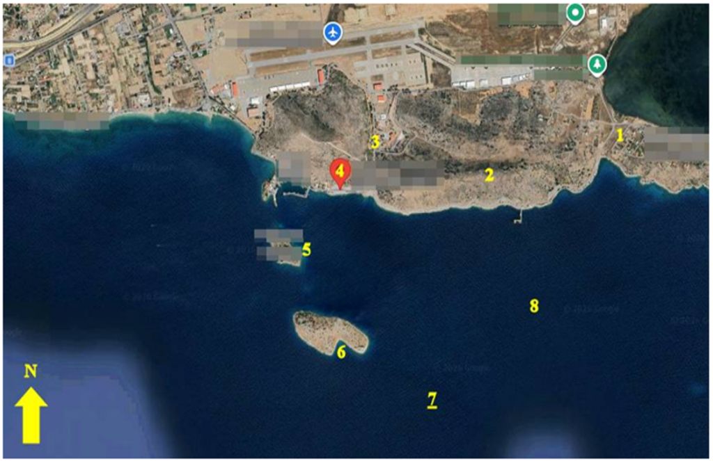
As previously mentioned, the focus here is on the optimal use of the three field technologies (UAV, UGV, TFC), rather than the operational details and SAR planning.
Due to the urgency of the situation, multiple SAR aspects where activated in parallel, even while the BoO was being set up. One RIB was tasked for coastal search around the two small islands (#5, #6) and the other for wide area surface search from the LPS (#7) and along the main drift (#8). One sensing/mapping UAV was tasked for wide area search along the main coastline (#2), due to lack of easy access after the landslides there. The transportation UAV [9] was tasked for carrying and dropping the UGV at the smallest and more flat island (#5) for rapid area search; when completed, the pilot was freed to deploy the second sensing/mapping UAV over the sea near the shoreline (#8) but not further away (#6) due to flight restrictions and harsh weather conditions. One of the two available FR teams was immediately dispatched for land search towards the hill slopes and shoreline (#2), while the second was dispatched very close to the BoO (#4) to the crossroad (#3), being a reserve unit and ready for re-deployment elsewhere if needed. The scuba diving team remains on standby, in case debris are located near the shoreline or as wrecks somewhere.
A mandatory status reporting protocol every five minutes was communicated to all teams dispatched in the area, while the BoO team kept monitoring the news feeds and social media for any new information worth of investigating regarding victims detected, weather conditions, etc.
Lessons Learned
The operational plan described above is heavily dependent upon the three field technologies analyzed. UAV deployment is of utmost importance, especially in the first phase (wide area search), but only of external conditions permit and there are available pilots. Remote sensing is their main advantage, but at the option of dropping a UGV quickly at the small island (#5) saves a lot of time: A full FR team and one of the RIB should be reserved otherwise, for a significant amount of time. Instead, this option is kept for the second phase of operations and only for the largest island (#6). Furthermore, due to the terrain type and landslides, the UGV would probably be unfit for such a deployment elsewhere in the area.
The UAV and UGV cameras, as well as the hand-held cameras from the deployed FR teams, can send images and even video streaming directly to the BoO for complete situational awareness, team safety and optimized tasking. Of course, in order for all these to work in perfect collaboration, a highly reliable and robust package of portable TFC must be available from the moment the team arrives at location (#4) and with an actual coverage of at least 2 km in range.
One of the challenges and debate regarding operational planning is where in this case the transportation UAV should take the risk (weather, link loss) and drop the UGV at the largest island further away (#6), keeping both sensing/mapping UAV thereafter closer to the smaller island (#5) and coastline for denser search patterns. This tradeoff becomes irrelevant if all UAVs, including the transportation, can be multi-aspect covering at least some IR/thermal sensing capability, even at the expense of maximum payload limit.
The other challenge, or rather a future feature to think about, is having UAV platforms that can be launched safely from small boats like RIB, even in rough sea condition and thunderstorm. If such an option was available, then one of the UAV teams could be immediately dispatched with a RIB and kept mobile throughout open-sea (#8) and more remote locations (#6) for rapid search sweeps.
Finally, in the context of TFC, a portable and completely autonomous “repeater” module capable of being carried by the transportation UAV could be dropped on top of the largest island (#6), thus ensuring very reliable and extended area coverage for many hours, probably until the end of the SAR operations.
Conclusion
Each of the technologies has invaluable advantages, which become even more significant when combined together: UAVs are fast to deploy and conduct rapid area search, but they need to be multi-aspect; UGVs are slowly, but can save time when they can be air-lifted; everything depends on reliable communications.
As analyzed in this study, the operational profile of UAVs and UGVs is quite different, but also complementary: The first focuses on speed and terrain-agnostic operation at the cost of coarser area scanning and sensitivity to weather conditions, while the second focuses on exploring specific locations with better sensing capacities (payload) at the cost of slower speed and mobility limitations due to terrain. In both cases, reliable communications to and from these platforms, as well as the FR team, is of vital importance for mission success.
Acknowledgements
This work is funded by the EU Horizon Europe research and innovation programme under grant agreement for projects CARMA (GA n.101168355) and 6G-VERSUS (GA n.101192633); and jointly by the EU Horizon Europe research and innovation programme; State Secretariat for Education, Research, and Innovation from Switzerland; the Japan Science and Technology Agency; the Korea Ministry of Science and ICT, and the Korea Electronics and Telecommunications Research Institute, under grant agreement for project SYNERGISE (GA n.101121321).
References
- M. Ciesa, S. Grigolato, R. Cavalli (2015). Retrospective study on search and rescue operations in two prealps areas of Italy. Wilderness & Environmental Medicine 26, pp.150–158.
- R. J. Koester (2008). Lost Person Behavior: A Search and Rescue Guide on Where to Look for Land, Air, and Water. dbS Productions, Charlottesville, VA, 2008.
- D. C. Cooper, J. R. Frost, R. Q. Robe (2003). Compatibility of Land SAR Procedures with Search Theory, Technical Report, Potomac Management Group, Inc. Prepared for the U.S. Department of Homeland Security, United States Coast Guard (G-OPR).
- L. Marconi, C. Melchiorri, M. Beetz, et.al. (2012). The sherpa project: Smart collaboration between humans and ground-aerial robots for improving rescuing activities in alpine environments. 2012 IEEE International Symposium on Safety, Security, and Rescue Robotics (SSRR’12), pp. 1–4.
- Z. T. AlAli, S. A. Alabady (2024). Techniques and methods for managing disasters and critical situations. Natural Hazards, vol. 120, no. 8, pp. 6943–6989, Jun. 2024.
- N. Zhao, W. Lu, M. Sheng, et.al. (2019). UAV-assisted emergency networks in disasters. IEEE Wireless Communications, vol. 26, no. 1, pp. 45–51, 2019.
- H. Georgiou, A. Vlachopoulos, A. Andriopoulou (2025). Resilient Tactical Field Communications for AI-enabled Services in Search and Rescue Operations – 6G-VERSUS. SafeHeraklion: New technologies for Civil Protection services (SafeGreece 2025), 22-25 Oct 2025 @ Crete, Greece.
- H. Georgiou, A. Andriopoulou, A. Vlachopoulos (2024). Evolution of Urban Search & Rescue (USAR) operations with remote sensing and information management via emerging ICT and robotics technologies for field deployment. Information Technology in Disaster Risk Reduction (ITDRR 2024), 14-16 Oct 2024 @ Krems, Austria.
- F. Steinhausler, H. Georgiou (2022). Detection of victims with UAVs during wide area Search and Rescue operations. IEEE Intl. Symposium on Safety, Security and Rescue Robotics (SSRR 2022), 8-10/11/2022 @ Seville, Spain.